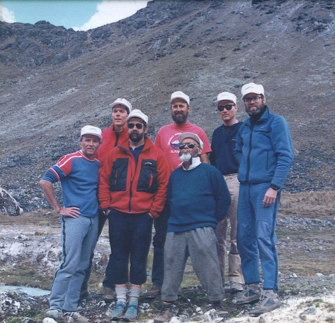
 Members of the U.S. Real' Time Expedition, the successful 1989 exploration of Bolivia's Cordillera Real (left to right) are: William Wolf, Peter Delmissier, Billy Bays, Steve Norris, Eddie Boulton, Kevin Spooner & team leader John Hessburg. Norris, Delmissier, Boulton & Hessburg were climbing buddies in Seattle, then & now the nerve center for alpine climbing in North America. Eddie was well into his 50s at the time, 20+ years older than the rest of us. Our team nickname "The Geezers" was inspired by Eddie's vigor, impudence & his "Damn-the-Age-Stereotypes, Full-Speed-Ahead" kind of grit. © Copyright 2016-2020, U.S. Dive Travel & The Diction Aerie. All text & photos, all rights reserved. By John Hessburg, Founder The Diction Aerie & USDT Network A friend at a recent party asked me this killer question -- THE Burning Career Question in fact -- one I'd never properly answered, even to myself: How in heaven's name did a Seattle newspaper reporter, whose passion was alpine mountaineering in climates high and dry, ever end up in the tropical diving business, with all that sticky heat at sea level? Funny thing, how it all came to be, gripping my focus for 27 amazing years on the Big Blue -- that place of peace and freedom where oceans meet the sky... "… We are not the fastest & we are not the best, Most of us are candidates for cardiac arrest, If we make it to Camp One, we'll all feel mighty blessed, And the Geezers wheeze along ..." That was the intro to our tongue-in-cheek fight song, "Geezers on Pumori," a caterwauling parody of "Glory, Glory Hallelujah" that carried the name of our dream peak, right next door to Mount Everest in Nepal. We wrote it to rev up the boys for shoulder-grinding gear hauls to high camp. But weird things happened, happy accidents. There were amazing quirks of chance intersecting with providence, all of which changed our lives forever. Fact is, the alleged Geezers -- all but one in our 20s and 30s -- never even made it to Pumori base camp. And as Robert Frost said: "That has made all the difference." Now today, nearly three decades later, it's time for the back story on how that Pumori fiasco led to the most wondrous alpine adventure of a lifetime, an expedition so full of health and high humor that a few months after we returned to the USA, it jump-started the founding of U.S. Dive Travel. That's right. A mountaineering expedition to landlocked Bolivia actually sowed the soul seeds of an agency dedicated to planning tropical island vacations. Go figure ... Shortly after that Bolivian Andes expedition, I felt so driven to dump the world of desks and dress shirts, to recoup the taste of sunlit freedom, so compelled to see more of the planet's mountains and oceans, that I left the worried world of metro daily journalism for keeps. Never once looked back. Not one person who knew us ever guessed our New Horizons would be over luminous South Pacific atolls instead of crevasse-lined Andean glaciers. All because seven ordinary working men from Seattle were blessed for two months to climb in "Real Time" in one of the Western Hemisphere's few remaining unexplored corners. Some prime valleys on the eastern flanks of Bolivia's Andes are so remote, so difficult to reach that no expeditions ever took the time to try. And that was our inestimably good fortune, to stumble on twin plums of Andean exploration -- the towering sister peaks of Chachacomani and Chearoco -- right when we needed them. The memories still linger, strong and glad like a kid's elation as he first steps off the bus when school is out for summer … All the mania started in the drizzly Pacific Northwest winter of 1988, when Seattle climber Eddie Boulton and I, along with a couple other American friends and three Annapurna veterans from Mexico City, were scheming on a new route up Pumori, neighbor peak of Mount Everest. We had a thrilling new route picked out, just ripe for a first ascent. It was a bracing, aesthetically beautiful ridge line -- steep but clean -- that somehow escaped the clutches of Himalayan climbers for nearly a quarter century in the Khumbu Glacier sector of Everest. Virgin rock and ice like that, routes that wild and untrampled are more rare, more coveted than peach-sized rubies. Our team was ready to rock. We had the Nepalese government permit and were locked into an $11,000 gear order with a premier Seattle outfitter. Then bam! … Only a few weeks away from stuffing duffel bags, a truth avalanche smacked us upside the head. Our Mexican partners hadn't lifted one finger to raise their share of the team budget. Assuming we were all rich gringos, they decided the Seattle guys should pay for the whole bleepin' trip. No gracias, boludos! So we were stuck with a truckload of gear that littered Eddie's basement like battlefield debris, not to mention 400 T-shirts pathetically trumpeting the Pumori mountain climb that never was. My cheeky kid brother still sings out "how's it goin' Pumori Man?" at family reunions, milking that vulnerability for all its worth. But life goes on. Good dreams die hard. We seven alpine bro's paid our debt to the outfitter, gathered our gear and re-energized our resolve. As expedition leader I hit the alpine libraries like a mole on double cappuccinos. And there was frenzied research... After a couple weeks of spirited digging, the upshot was a jolt. Pumori wasn't looking so seductive anymore; not at all. We were flying in the face of conventional climbing community wisdom in those days. Nuts to the noise of the shopworn Everest region. Even then Mount Everest was getting loved to death by greedy guide services who readily plastered that once sacred massif with (literally) miles of fixed ropes, flapping nylon tents in scores of gaudy colors, and gear caches -- including so many piles of spent oxygen cylinders that they'll remain forever -- a heart-sickening testament to crass environmental exploitation. We decided the place to be was not the garbage-flecked and trekker-ridden Khumbu Icefall sector of Nepal. Instead, it was the Cordillera Real', the Royal Range of Bolivia's seldom-visited central Andes sector. This is one of the least accessible regions of the vast Andes chain and therefore it held promise for high adventures and low tourism. But what a daft paradigm shift: from glorious Pumori, sister peak of Everest, to... to Bolivia! Really? What were we thinking -- Bolivia ?? Oh yes indeed. Unsung jewel of the Andes Mountains, Bolivia is a fresh and curiously innocent country, poised to become a new Mecca for adventure travelers with a yen for serious wilderness at bargain prices. The eastern slopes of the Cordillera Real', pristine, remote and graced by perfect climbing weather -- cold, clear and normally calm from May through July -- offer countless possibilities for new routes on peaks 18,000 to 20,000 feet high, in one of the wildest sectors of alpine terrain anywhere on our stressed-out planet. For perspective, the tallest peak in North America is Denali in Alaska (Mount McKinley) at 20,310 feet a formidable challenge. Peaks of this altitude and technical complexity are flat-out dangerous, any season. For example, Denali has claimed more than 120 lives since 1932. Anyway, to hell with the stats -- the Cordillera Real' -- now we had an objective... Driven by the deadline of a narrow best-weather window, I hit the phones in February 1989 like a man on fire, lined up a seven-man team from across the U.S., and arranged a three-month leave from my reporting job at the Seattle Post-Intelligencer, then the Northwest flagship of the Hearst newspaper empire. Early May was spent in La Paz -- world's highest city at 12,000 feet -- building red cells, lining up llamas, trucks, food and fuel, and training on nearby Huayna Potosi, a splendid 19,996-foot pyramid of ice and wind-packed snow. We narrowly missed the summit of Huayna Potosi by a few hundred feet, a one-hour ice-ridge stroll, driven back to base camp by a blinding snowstorm that blanketed the upper peak with deadly avalanche potential. But that freakish storm, rare bad luck that time of year, was only another Pumori-like enzyme, catalyzing the team's esprit even more. We were so fit, so stoked after two weeks of high altitude training on the more accessible western flanks of the Cordillera, we felt ready to gargle barbed wire. By the third week of May 1989, my team was heading for fresh terrain in the heart of Bolivia's winter, full of imaginary youth, high hopes and hearts hankering for a wilderness infusion of uncommon purity. After the stinging disappointment of Pumori, it was clear the only way to enjoy this expedition game was to cut loose, stop taking our previously lofty Himalayan objectives -- and ourselves -- too seriously. The North American and European mountaineering scenes of the 1980s were so self-conscious and hubris-soaked as to be caricatures of Narcissism. The Puget Sound region was rife with stuffy young climbers, putting on airs, boasting about their weekly brushes with death, trying to out-cool one another with head games and flamboyant media manipulations. It was like some Monty Python skit about the Ministry of Silly Walks, with all the characters moving in fast-mo and addled by oxygen debt. So we sought a far different soul vector for this Cordillera Real Expedition. Something leaner, cleaner, lighter in spirit. Here's where we got our team's official name, the one we put on our new T shirts with a breezy Vapor Wave logo: "The 1989 Real' Time Expedition." I remembered a spirited interview about four years earlier with Howard Roberts of Edmonds, WA, one of America's top session guitarists from the 1960's through the 1980's. Howard, who became one of my dearest friends in the Emerald City of Seattle, had played on more than 50,000 singles, jingles and TV commercials. He'd backed up Elvis, the Stones, the Beach Boys, plus he laid down monster guitar tracks for dozens of hit rock tunes and pop-culture classics like "Shadow of Your Smile." Howard Roberts, whom we nicknamed "The Phant" (for Phantom) is the man who played that rollicking "needle-needle neet-not" intro to the 1960's classic Beverly Hillbillies TV theme. He also played the eerily unforgettable "dee-dee dah-dah" licks that kicked off Rod Serling's original Twilight Zone show. Howard was a fascinating guy, and I admired his casual outlook on urban life, the way he relaxed 120% into his art form, avoiding social pressures and status symbols like they were leprosy. Good ol' Howard Roberts praised the crazy energies of playing guitar -- actually doing anything you love -- in "Real Time." That was his label for an almost sacred state of flow that comes when you shuck the workaday world of worry, competition and striving to achieve. Instead you reach for humor, creative exploration and free-floating improv. Kind of like kids playing on a tropical beach while their parents look the other way. Inspired by Howard's artistic freedom, I resolved that this expedition's goal would be to have no rigid goals at all. None. We'd just go "Climbin' in Real Time" -- and to hell with Madison Avenue and big media. The idea was for seven guys to jump headfirst into an alpine jam session, and simply see where it led. "Climbin' in Real Time" would be spontaneous, impish, childlike yet bold and colorful like Aurora Borealis, the Northern Lights, which are "what rainbows do when the teacher leaves the room," to quote my buddy Bob Shaw. The Real Timers would embrace our mountain rather than "conquer" her. What a singularly lame idea -- "to conquer a mountain" -- as if it were some malevolent adversary who must be whacked into submission, so the world can be safe for democracy again. I checked with the guys and they were all on board. Howard's "Real Time" ideas resonated. Thus the Real Timers chose, instead, to place team safety ahead of personal acclaim, spontaneity ahead of summit fever. We would climb with a calculated rebellion against some selfish and suicidal thinking that has sullied the art-sport of alpine mountaineering today. If you scan the major climbing magazines, for much of these last three decades one noisy Bolshevik faction has lifted "extreme alpinism" to the pinnacle of respect. They worship its kamikaze-death-commando style and confer pop deity on its handful of cocky practitioners. Year after year, these self-anointed "hard men" gouge out faster, steeper death routes, after which they regale the masses with tales of Cheating The Reaper, oh so adroitly. In short, too many alpine climbers, too many rock climbers, have been taking themselves way too seriously. For way too long. While the magazines keep trotting out new solo ascents of incredibly desperate rock and ice routes, they overlook the fact that novice climbers in high school and college -- of whom there are hundreds in the Puget Sound region, also in Oregon, California, Montana, Wyoming and Utah -- yes novices devour these articles as if they were Holy Writ. Many alpine newbies assume this is the standard of the sport, the level to which all mountain men and women with certifiable red cells must aspire. And this lunatic assumption is still killing climbers, year after year. So many dear old friends from Seattle, men and women alike, died chasing these delusions in the 1980s and the 1990s. Their smiles, their favorite turns of a phrase, often revisit me on quiet evenings when I am sitting alone in my office, reading. Like my Dad used to say: "Death is nature's way of suggesting you slow down." The typical American mountaineers are weekend warriors with regular jobs, family ties, moderate incomes and limited free time to train. Thus, the so-called "standards" of extreme rock and ice routes that are waved in our faces by the full-time gear-hawking pros are so far removed from reality as to be extra-terrestrial. There are no standards that matter -- except fun and safety. Period. That's why I made a decision: it was high time to celebrate -- and encourage -- the modest exploits of the ordinary mountaineer again. In short, it is a healthy thing to look up to -- not measure up to -- the alpine mountaineering superstars. Let them zoom about in their own eccentric orbits. We will keep our boots firmly on good ol' Mama Earth as we ascend to our chosen summits, maybe a bit more carefully with our feet of occasional clay. So … here is the gist of this Revolution of the Regular Guys and Gals:
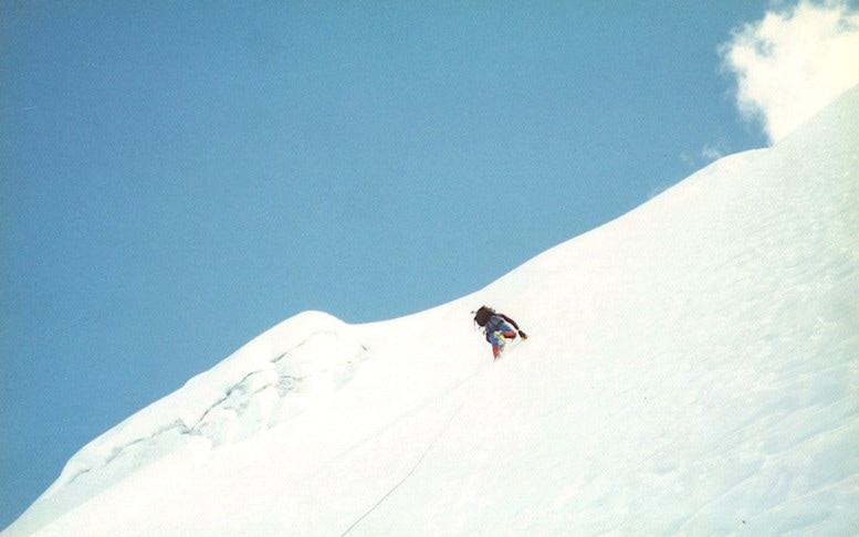
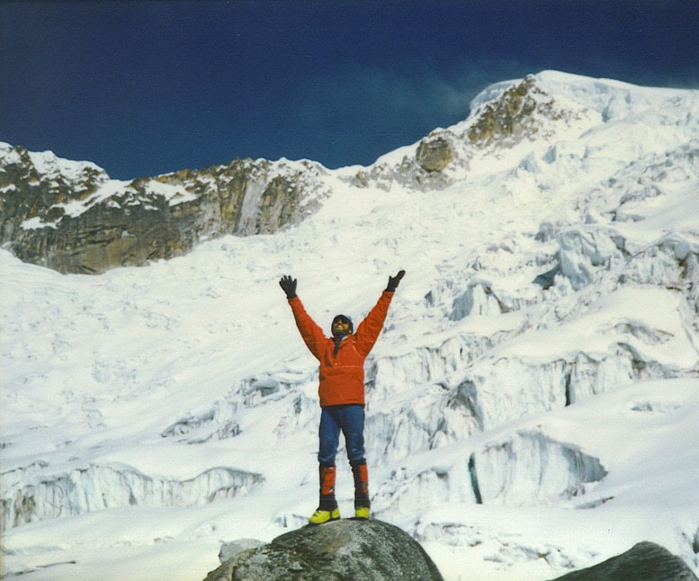 © Copyright The Diction Aerie. All rights reserved. Members of the 1989 U.S. Expedition to Bolivia's Cordillera Real', enjoyed perfect weather & ideal snow conditions, crisp & stable, at a 16,200' high camp (Camp Susana) beneath the wind-lashed summit of Mt. Chachacomani, 19,902 feet. Five Americans on that team reached both summits of Chachacomani, completing a first ascent of the elusive Northeast Ridge, which looms over miles of shifting icefalls below. And here's how we cranked out the prelim logistics for this Andean mountaineering adventure. We first spent a couple days researching aerial photos in the archives of the Bolivian Military Forces HQ in La Paz, who graciously donated bird's-eye above-summit views impossible to secure anywhere else in the world. We now had our window on the wildest unexplored sector of the Andes Range! We were excited beyond measure. Then it took nearly a week to filter the white kerosene, purchase mountains of sausages, rice, lentils, beans, hard rolls, noodles, quinoa grain, powdered milk, dried fruits, and pack all the provisions into more than 80 ten-liter reinforced plastic water bottles -- the narrow rectangular kind with handles on top -- just perfect for sliding into a llama's skinny saddlebags. Approaching from a swing to the eastern slopes -- the hard way -- The Real Time Expedition explored two remote high alpine basins in the Cordillera Real. After our successful expedition returned to La Paz, securing permission from both Bolivian climbing officials and local Aymara Indian leaders, we officially charted and named both of our newly-explored high alpine basins and all their primary geologic features. We registered all these new topographic names -- for the massive glaciers, ridges, the ice faces and the high alpine plateaus -- first with Bolivian officials then with the American Alpine Club (USA's mountaineering archives) to whom we donated detailed route maps we had drawn. Records of previous European and Argentine expeditions to Mount Chachacomani, both of which climbed from far easier western approaches, are sketchy. There were no official topographic maps of this sector and existing hand-drawn maps are of questionable accuracy. Other lesser expeditions on the more accessible western approaches never reported their routes. We did our mountain archive research with good faith and due diligence. To the best of our knowledge, therefore, we earned three first-ascent routes to summits on the eastern flanks of the Chearoco-Chachacomani Massif. More on all of these later... Distinguished by two 20,000-foot sentinel peaks, towering pink-granite walls and hazardous icefalls riddled with crevasses up to 150 feet deep, plus 30-to-50-foot towers of teetering ice blocks called seracs, this 8.7-mile-long massif is one of the principal geologic thrusts of the Central Andes. Its southernmost crags are located about 44 crow-flight miles north of La Paz, the capital of Bolivia. First there was a Land Rover caravan over 75 miles of lumpy dirt roads, across the Altiplano. Then a strenuous three-day approach march, with a huge llama train in tow, took us over three passes that averaged 15,000 feet in altitude. Again, to the best of our knowledge, we are the only modern-day explorers ever to traverse these high passes in succession, en route to an alpine cirque of cathedral beauty the Aymara natives call "Chekap Kuchu," or "Valley's End." Since 1962, a couple expeditions visited Chekap Kuchu before us. But they completely missed the two most beautiful of the neighboring valleys, hidden far above their lines of sight at Island Camp. Our good luck! Alpine journal records show we apparently were the first non-indigenous people ever to penetrate and fully explore, from a base camp below Chearoco's Northeast Face, the two magnificent high alpine basins to the northwest and south of Chekap Kuchu. Each day we hiked, hauled gear, refined our camps, cooked, chowed down, washed our faces in 45-degree glacial water and rested in those magnificent virgin basins, we thanked the Good Lord above for this ineffable delight, for this privilege of living for a moment in an untouched part of Planet Earth so remote that, most likely, no other human beings ever had camped there before. This is a feeling so electric with happiness and awe I still, years later, never have been able to explain it fully to my family and friends. It felt like kissing the outstretched hand of God. And it transformed my life with an overwhelming peace and confidence... just being there, risking so much time and treasure, no safety net, no rescues possible, breathing the thin clean air and soaking up the perfect weather, the looming vistas, the high alpine sunshine. Even half-cooked lentils with stale rolls tasted like heaven-sent manna in Chekap Kuchu. And this is where the seminal idea was conceived, the spirit of brushing fear aside, of risking more than you'd ever felt possible, of leaping into the absurd and creating a new logic, seeking a healthier life than one the corporations dole out, on their terms. We rewrote our own terms. From the Andean Altiplano to South Pacific atolls... The spark that lit U.S. Dive Travel actually jump-started not in the Pacific islands but in the Andes mountains of Bolivia! Now back to the gnarly business of the approach march to base camp, always a gringo grind. If your approach goes sour, it can wreck an entire expedition before you even hit base camp, so we planned ours with impeccable caution. We were helped by five Aymara tribal herdsmen whom we had hired in Jankho Khota village back about 48 miles below "Base Camp Numero Uno." They were humble slightly-built young men with earnest eagle eyes and dark bronze skin, whom we treated like gold, because their advice and route-finding wisdom were pure gold. I also hired a 19-year-old kid back in the village named Froilan Guarachi, to serve as our camp cook and to guard the tents while we were away on summit days. Froilan was loyal, cheerful and patient, never once griping or sulking, as some of us "Soggy Seven" did after daylong gear hauls to high camps. Good grub does so much for an expedition's spirit. It wasn't just the calories we craved -- but the "campfire TLC" after a grueling day of lugging provisions to high camp. Froilan's meals and hot beverages were like benedictions, day after day, and our team morale remained as high as the imposing summits above our camps. Actually higher than three of those summits, as soon we'll see… Now, back to the approach hike, which is to a successful alpine exploration as concrete-and-rebar foundations are to skyscrapers. Starting at that lower elevation village, about 11,000 feet, for three windy 12-hour days, hiking about 48 miles, we herded a caravan of 49 spirited llamas laden with 2,200 pounds of food and gear, over three 15,000-foot passes to reach advance base camp. We built our operations base, called "Island Camp," at 14,100 feet (nearly the same altitude as the highest summits in the Lower 48). Island Camp was ideally lodged at the confluence of two rushing glacial-melt streams that swept around a wide lump of flat grassy ground and created an oval-shaped "island." There we camped for 5 weeks smack dab under the forbidding Northeast Face of Chearoco (20,072 feet), just outside the reach of any avalanche chutes. We pitched 6 roomy North Face VE-24 dome tents: 4 for sleeping, 2 for gear stowage. It was a base camp paradise in every way. Best campsite I'll ever know on Planet Earth. Once more, back to that pesky reality. Yes, there were some epic moments on the approach hike, such as one afternoon when the second pass we reached, just into the 16,000-foot altitude zone, was too high for half the llamas. These fuzzy beasts got so bushed they simply laid down and panted like sick dogs in a summer heat wave, refusing to budge another inch. I could feel my heart sink that day. "Aw damn it, not another Pumori!" Mind you, we already had been pampering those llamas to a faretheewell. We cautiously kept the weight loads under 48 lbs for each llama, on the advice of our local herdsmen, so we would never stress-out their cardio-vascular capacity and exhaust them. And we used llamas, not mules, because the latter specie is not only stubborn, but rarely can lug any helpful weight above 14,500 feet. Llamas in the Andes, like yaks in the Himalaya, are the strongest high-altitude porters in the world. Even as easy as we were on our 49 long-necked cud-spitting llama buddies, we apparently brought them to the very envelope of llam-anian endurance. So I was forced to relent, and we let those bleepin' llamas take so many breathers that they stretched our approach hikes from dawn to dusk and had me fretting like a ferret. Man, we kept on burnin' daylight, copiously, day after day. But when you're a climber with eyes on a prize, the beat goes on … The second llama epic occurred on day two of the approach hike, when the alpha male rounded a blind corner on an extremely steep and narrow pathway, then he turned and bolted back down that trail with a wide-eyed look of panic. Several other llamas began to go AWOL, too. Pretty soon the whole herd of 49 was balking, groaning with anxiety, skittering about like water beads on a hot-oiled griddle. We had a mammal mutiny on our hands. "What now?" I thought with a hot tar pit in my stomach. Turns out that only hours earlier, a massive rockslide had thundered down that pass on the right-hand side where we were hiking, completely obliterating the trail with truck-sized blocks of cold gray granite and vast piles of ankle-bending rubble. The only way up was 70-degree ledge-infested rock climbing, Class 4 -- which nimble 2-legged humans with 50-lb packs can do a lot better than 4-legged llamas. The 49 llamas would have nothing to do with that rockslide-ruined pass. They hated even looking at it. We were in deep llama-doo and something had to done -- but quick. So I ordered the herdsmen to strip the saddle packs from many of the weaker animals, and we pathetic humans dragged those bags, one by one, to a higher plateau, then returned for the llamas. By then those frigggin' critters were resting blithely below the rockslide, like it was Picnic City, while we gasped and sweated, doing all their grunt-work for them. I scouted a slightly easier detour route to the west, and we then were forced into the hilarious indignity of standing squarely beneath hairy dirt-clumped llama rumps, pushing with all our might to get a 240-lb beast up onto the next rocky ledge. One ledge, one llama at a time. Yep, just as you might guess, when llamas get stressed and pressed from behind their hams, they sometimes choose to whistle the metabolic music of their last grassy lunch -- in a manner most politely described as "The Winds of Doom." Ai caramba... Did we really sign up for this? Finally after 4 hours of shoving wooly llama butts skyward, grunting like ruddy-faced farm blokes, zero humor left in the tank, we skirted the worst of the avalanche debris and crested that windy snow-swept pass -- some 16,200 feet in elevation. Then elated as schoolboys at recess we charged 3,000 feet down the back slope to our second approach camp just in the nick of time before sunset -- spent but triumphant -- all 49 llamas in tow. Not a single beast was hurt; not even a scratch. Late on the third day we arrived at Chekap Kuchu, base camp was set without further ado and we rested like half-dead coal miners after dodging a cave-in. A few days after we set Island Camp, we also hauled heavy packs up for three days each, establishing three additional high camps at 16,200 feet in separate valleys. From there several summit bids were launched. 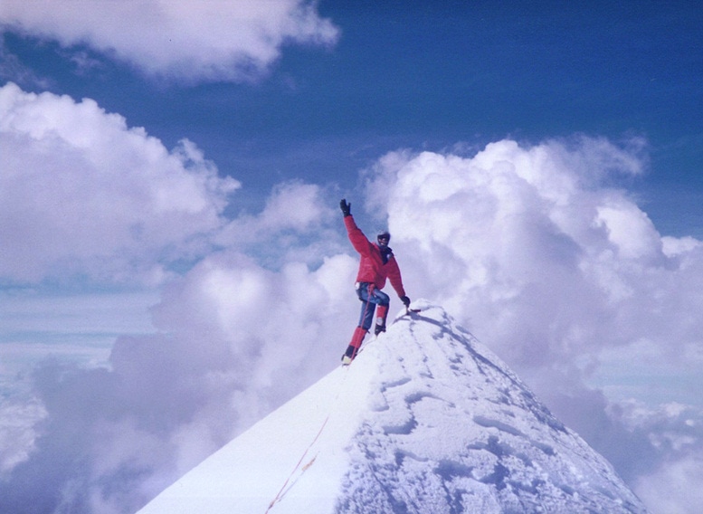 © Copyright U.S. Dive Travel Network & The Diction Aerie. All rights reserved. John Hessburg waves from the cloud-kissed summit of Mount Chachacomani (19,902 feet) in Bolivia's Cordillera Real' -- the remote Royal Range -- after a hard-won first ascent of the elusive Northeast Ridge . These were the inspiring summits we reached with the Good Lord's gift of perfect weather for two months, sunny and cold, plus solid snow conditions and low avalanche risk on most slopes: (1) First ascent of Mount Chachacomani (19,902 feet) via the full Northeast Ridge, as approached from the northeastern icefalls. We were turned back once but tried again two days later. I refused to give up that route-finding nightmare, not as deadly as Everest's Khumbu Icefall, but close enough to keep us on red alert for three nerve-flaying days. I kept at it, returning to the route again and again, planting marker stakes and finally found a convoluted way through the glacial labyrinth, that required no ladders or fixed ropes. Just sharpened crampons, shin bones and elbow grease. On June 6, 1989 we wove through a 2-mile maze of crevasses and ice pillars, then traversed up the base of the Northeast Ridge, over a couple tricky ice pitches to the North Face, and on to the skinny ice blade of a summit. Peter Delmissier, Eddie Boulton, Steve Norris and Kevin Spooner joined me on the summit, each of us taking turns to stand for a few minutes on the absolute crest of Chachacomani. It was a perilous place; no room for a barn dance. Maybe 10 or 12 square feet of knife-edged ice cornice bounded on the west by a sheer 4,000-foot ice wall, on the south by a steep slope of hard-packed neve (old sun-baked snow) and the runouts were all terminal falls in 3 directions. So we took our time, took the photos gingerly then cramponed step-by-deliberate-step off that peak before any storm could roll in and trap us. Another thing I'll never forget: the warm American pride we felt when we planted a small USA flag at each of the summits of Chachacomani, buried tightly under the snow so they would never litter the mountain. What a day of joy and satisfaction. We had reached the key summit we were seeking for months! Thank you Lord! I led the rope team up and down without a single injury, though Steve-a-reeno on the descent, just below the summit blade, slipped into a crevasse up to his waist. The rope team wisely had left very little slack between men so his fall was Mickey Mouse. We were able to yank him out in less than a minute. On all these pioneering routes, we left Camp Susana a couple hours before dawn to be safe and sound, just like we'd trained on stateside Mount Rainier earlier that spring. The climbing schedule flowed like buttermilk. Five of us reached the higher Northeast Summit of Chachacomani in nine hours from high camp, then we hiked southward about 400 yards across a high saddle, wading through deep drifts to the second Chacha summit for good measure, and were back down to Camp Susana by dark. Our view from atop "Big Chacha" was impossible to forget: a 360-degree vista of Lake Titicaca and the Peruvian Andes to the west and north, and the fog-shrouded tropics of Brazil's far-western Amazon headwaters. To the south we could see hundreds of square miles of the Bolivian Altiplano. We were right there, up in the scudding clouds, tasting the weather in our front teeth, gripping the rooftop of the Central Andes with our trembling fingers. If ever I've felt more alive, I don't remember when. But there was still more for the Andean alpine archives … (2) Solo first ski descent of Chachacomani's northeastern slopes - from the Northeast Ridge to high camp -- by Mercer Island WA's Peter Delmissier. Peter plied an astonishing crevasse-filled two-mile icefall we named "Ome Daiber Glacier" in honor of the late Cascade Mountain Range legend who pioneered Mount Rainier's classic Liberty Ridge. Peter needed maybe five minutes of his Unreal Time to "shred the descent" -- grabbing a little air time en route -- while we gaped, slack-jawed and prayerful. After resting a few days following the successful ascent of Mount Chachacomani, we were blessed to make this next summit in fewer than three days: 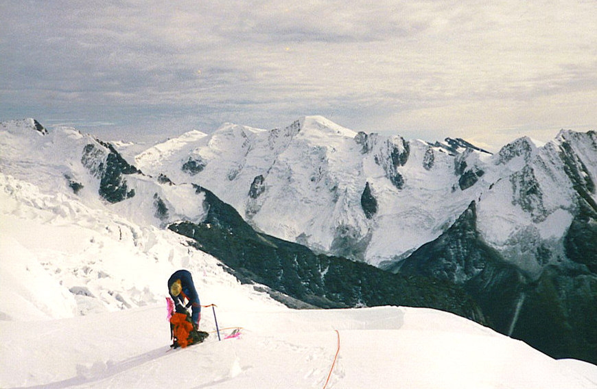 © Copyright U.S. Dive Travel Network & The Diction Aerie. All rights reserved. Climber Kevin Spooner takes five, a water break at 18,000 feet while descending Mount Chachacomani after the Real Time Expedition placed 5 climbers on the summit. Looking NE across Chekap Kuchu Valley at the virgin Southwest Face of Dome 2 (18,721 feet), which a week later was pioneered by 3 Real Timers. Camp Susana (16,200 feet), high camp for Chachacomani, was 1000 feet below Kevin, below his right shoulder in darkly crevassed sector of Ome Daiber Glacier. Camp Barbara (16,200 feet), high camp for Nevado Domine, was just over the dark "V notch" in distant ridge. The steep 400-foot Bonz Headwall looms just above the black teardrop buttress. (3) The first ascent of the Southwest Face of a new peak we named Nevado Domine (18,721 feet) -- via a steep 3,400-foot ice and snow route. Peter, West Seattle's Steve Norris and I completed the second ascent of the peak a British expedition labeled "Dome 2" in 1962. We named our high camp "Camp Barbara" after my mom, and the huge steep neve headwall after my best buddy Bob "Bonz" Shaw. Steve got to name a prominent ridge next to the headwall after his daughter Stephanie. And Pete got Nevado Domine's toughest crux named after him -- the Delmissier Step -- a tricky 25-foot stretch of nearly vertical ice framed below by a yawning crevasse that was, well, a bit deeper than we'd hoped for when scanning it from high camp with "binocks." When I kicked an ice clump down, it was a good five seconds before we heard a clunk. OK, take a deep breath, suck it up. Everything's gonna be OK. And it was because we went carefully, step by deliberate step. Over and over all day long and well into the night. Step by deliberate step. The stress of that concentration brought deep fatigue -- to the marrow of your bones -- by day's end. This climb of Nevado Domine dealt us some cruxes that were cause for a pause:
 © Copyright U.S. Dive Travel Network & The Diction Aerie. All rights reserved. Climbing leader about 50 feet below corniced crest of Bonz Headwall, a 65-degree 400-foot wall of ice and neve snow that guarded the final approach to the summit dome of Nevado Domine (Dome 2). Three Real Timers made summit. 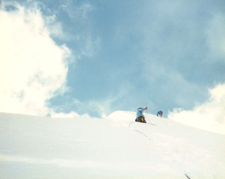 © Copyright U.S. Dive Travel Network & The Diction Aerie. All rights reserved. Climbing leader reaches summit of Nevado Domine (Dome 2) with two buddies, having completed 1st ascent of the Southeast Face, and 2nd ascent of the peak, which rules the hidden high alpine valley 7 miles east of Chachacomani. This photo by Peter Delmissier was shot just seconds before a sharp avalanche fracture cracked across the summit dome. Had the slab slid, all three of us would have died, and likely never been found in an Andean alpine basin that remote. There was one more noteworthy archival highlight of the expedition: (4) Solo first ascent by Billy Bays, Casper, WY, of the Northwest Ridge of "Diablito's Tower" (17,500 feet) -- an enjoyably moderate rock climb up a granite crest that dominated the northern terminus of Ome Daiber Glacier. We also named this prominence because it was smaller and "cuter" than the original upthrust stateside, just west of Sundance Wyoming. Billy worked so hard to get on this expedition. He almost had to bag it mid-way when I sent him down to below 12,000 feet, to an Aymara Indian village aided by one herdsman and one climber, to recover his health after he started developing pulmonary edema a couple weeks into the expedition. Pulmonary edema has been known to kill unwary climbers in their sleep at this altitude. So we were worried as can be. But Billy got some Aymara tea and TLC, and he felt better. He hiked back to Chekap Kuchu with a big wide grin and some lame jokes a few days later and we hugged him fiercely. We all were delighted later by his successful solo ascent of the beautiful rock pillar I named Diablito's Tower, about 450 feet of gain from the ridgeline. Now it was time for the team to celebrate, and boy were we in the mood to party! Back in base camp, we threw an apres'-summit bash for the team, and sent a herdsman as courier to invite our Aymara tribal neighbors, 12 miles down river, for the feast. We divvied up a precious case of La Paz beer the llamas had lugged in, and used it to wash down a whole sheep, barbecued on a spit that Peter Delmissier, my right-hand man, had improvised from battered aluminum snow pickets. It doesn't take much of the old suds to crack a smile at 14,000 feet after a week at high camp. By 8 p.m., Island Camp was hopping with music from a mini-guitar and a banjo we'd hauled in. Aided by annoying reserves of Everclear, smuggled into base camp by Seattle's Eddie Boulton (who ignored my expressed instructions), several of the guys had to grab hold of tall grass to keep from falling off the planet. Not stodgy ol' Uncle John, of course. The climbing leader always has to remain Stick-in-the-Mud + Rule-Enforcer + Anchor-of-Propriety. But I hate hard liquor anyway; always have. So I relished the chance to be designated driver with no wheels, at Island Camp beneath Chearoco Peak, that glorious evening. Several days later, after trying another steep ice route that did not work out, due to unstable boilerplate ice over a softer snow pack, we were sore and skinny as whippets. The avalanche hazard was high, we waited below the crux for an agonizing hour, studying the face, pondering, guessing then second-guessing. We turned back at 17,300 feet from what could have been a slam-dunk first ascent of the Southeast Face of Chearoco. Too hazardous. Not worth the risk, coveted prize that it was. We all had wives, girlfriends, families back in the USA who mattered way more than another notch on our ice axes. Then we called it a trip, left Chekap Kuchu and began the grinding 3-day march back to Jankho Khota village. We herded those rowdy llamas back to their home corrals, paid the herdsmen and gave them gifts, returned to La Paz, hurled ourselves at showers and real food, greasy spicy food oh yeah, and rested for a blissful 3 days of 12-hour sleeps and easy city strolls to get even more food. Each of us had lost more than 15 lbs during the two-month expedition. I looked like the poster boy for Kwashiorkor Ribs. Then that pesky reality intruded once more; we had to prep for the long trip home. Pretty soon freeway overpasses and skyscrapers would supplant Chearoco's magnificent ice wall as our morning wake-me-up vista. A little dread began to gather, mixed with butterflies-in-the-gut delight that we'd soon be seeing our special women. But first things first. Time to pay homage to our worthy host country. We threw a formal victory dinner for our Bolivian outfitters plus the local mountaineering honchos in La Paz. What a night of unabashed rejoicing and electric banter! Then the next morning, reluctantly, we flew back to the workaday world in Seattle. It was so great to hug my fiancée again, I immediately forgot how deeply depressed we felt to leave that alpine paradise. She seemed to glow with an almost unearthly beauty and her easy smile gave me hope that, yes, there still is sentient life back at our big city jobs. The newsroom seemed not as ridiculous a place to return to, once I was able to hug Susie again. Re-entry had begun. Later all of us recounted how the reunions with our loved ones was marred only by a little hollowness somewhere in the back of our heart. Tough to talk about. It nagged at me every day for weeks, beyond definition or understanding. I would get on the phone, call the Real Timers late at night and commiserate. And they would say right back to me, "yeah I know, I'm feeling the same thing too." All seven of us climbers were unprepared for "la petite mort," the little death that came in the weeks after those summits. It was a gnawing limbic pain, relentless. I'd struggled so hard to find an explanation, but never could. Now, years later, I finally understand what it was -- that sad restless feeling all the guys were grappling with for months... During that aching period of adjustment something good was happening, too, under the hood. That was when the New Confidence began to bloom like a century plant. Big fun ideas, wonderful thoughts of a new career, the hopes of starting a new adventure travel business. Heeding an inner voice that had been piping at the back of my brain for a couple years, I took the full sweep of PADI scuba diving courses all the way through Divemaster Training, then got the bug to visit Hawaii and the Cook Islands in spring 1990 for a splendid five weeks of sunshine, surf and sand. A few months after returning to the USA, buoyed by an astonishingly good time on Rarotonga and Aitutaki islands, I was smitten by the SoPac forever and decided to make the Pacific my workplace and the Rockies my playground. Somehow, after the Perfect Trip to Chachacomani in Bolivia, I knew U.S. Dive Travel would be blessed from its toddlin' days. And it was mates, it really has been blessed beyond expectations. No matter how intense of a joy any expedition may be, there's always the post-partum blues when you return to sea level and embrace the city madness again. You grow wiser in a punishing sort of way. You realize with clarity, with acceptance, that you'll never again savor exactly that same blend of humor, team esprit, adrenaline and cardio-pumping challenge. You'll never again be able to relive that precise confluence of discovery and joy. That time of magic has passed forever. But the bittersweet blues are salved by one certainty. You can climb any mountain, anywhere, in Real Time. Any mountain, literal or figurative. In fact, you can realize any dream you want in Real Time -- even one that connects folks craving getaways from beleaguered cities around the world to tropical islands like the jewels of Fiji and Indonesia and Papua New Guinea. That's it, sunseekers. That is where the sense of balance came from. That's how the inkling, the goal, then the reality of U.S. Dive Travel first were conceived. Not in the balmy blue seas of the South Pacific, but in the ice-crowned Andes mountains of Bolivia. Imagine that …
1 Comment
|
FRICTION-
|
 RSS Feed